4/1/2005
1/5/2025
Landmark information
- Location:
E side of Hwy 49 (PM 11.3), 2.5 mi N of Chinese Camp - Plaque:
Other Plaque - Site:
Nothing Remains - Date First Visited:
6/19/1998 - Date Most Recently Visited:
1/15/2025 - GPS Coordinates:
N 37 54.667, W 120 27.110
About this landmark
Plaque text:
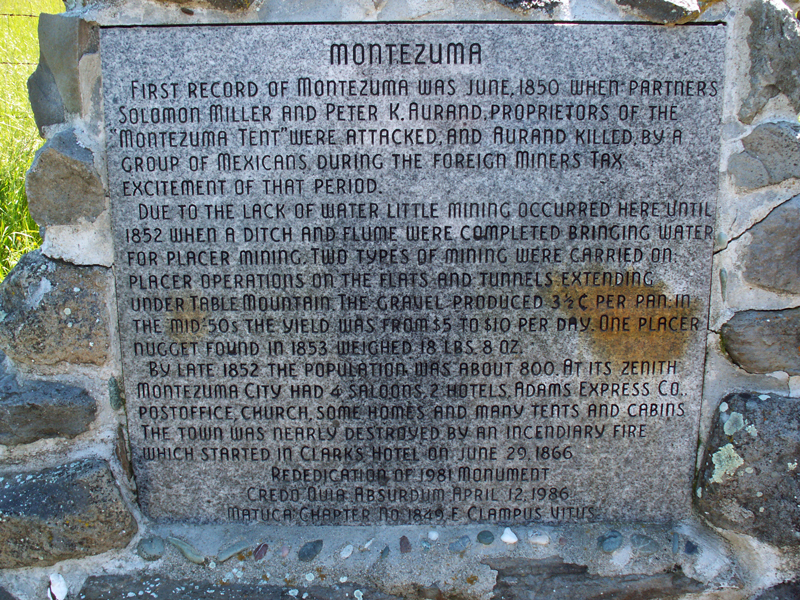
First record of Montezuma was June, 1850 when partners Solomon Miller and Peter K. Aurand, proprietors of the "Montezuma Tent" were attacked, and Aurand killed, by a group of Mexicans during the foreign miners tax excitement of that period.
Due to the lack of water little mining occurred here until 1852 when a ditch and flume were completed bringing water for placer mining. Two types of mining were carried on: placer operations on the flats and tunnels extending under Table Mountain. The gravel produced 3-1/2 C. per pan; in the mid-50s the yield was from $5 to $10 per day. One placer nugget found in 1853 weighed 18 lbs. 8 oz.
By late 1852 the population was about 800. At its zenith Montezuma City had 4 saloons, 2 hotels, Adams Express Co., postoffice, church, some homes, and many tents and cabins. The town was nearly destroyed by an incendiary fire which started in Clarks Hotel on June 29, 1866